|
The limestone hills of Malaysia come in all shapes and sizes. Generally they occur as single outcrops, but in some places, e.g. in Perlis and Gunung Mulu National Park they may be formed as part of long ranges.
Many of the sedimentary rocks were separated during the orogenic movements associated with intrusion of granite. The sedimentary rocks were folded into troughs and the granite cores between them were exposed by erosion, resulting in separation of the areas of sedimentary rocks. This is noticeable in the isolated limestones of east Perlis, Baling, Perak, Selangor, west Pahang, Kelantan and Terengganu. Much of the Kuala Lumpur area is formed of limestone which is estimated to be 6000 feet thick (Gobbett 1963). Zeinab (2009) says approximately 40% (236.827 km2) of the Kuala Lumpur area is underlain by limestone. However the only actual outcrop is Batu Caves.
In Peninsula Malaysia the outcrops can be seen in all states north of Kuala Lumpur up to Thailand, except for Penang. Driving along the north-south highway in Perak takes you past many limestone hills, especially around the city of Ipoh in the Kinta Valley.
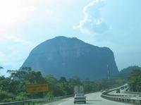
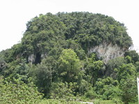
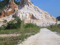
Travelling north from KL, if you take the old trunk road you see the two hills at Templers Park. However you miss these if you use the highway. The first of the Kinta Valley hills is Gunung Gajah - Tempurung. On a clear day you get a stunning view of the distant hills after the road passes close to the Tempurung massif. After another 10 km or so, you start to see these hills close up. Some are fine hills still covered in untouched rain forest, others have been damaged by quarrying which has left ugly stumps of hills. Nearer to Ipoh the highway passes through a valley with hills on either side, some of which have been desecrated by quarrying. There are many marble workings here.
Bukit Anak Takun |
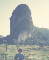
Gunung Gajah |
Gua Kandu |
Some hills are blasted to obtain the limestone which is used in the cement industry and also for road building. Other hills which have marble are treated more gently, as the marble is extracted in large chunks, to be used as decorative stone.
Further on, Gunung Lang has been turned into a water recreation park, although it cannot be seen from the highway. You might catch a glimpse of the pagodas on top of the hill at Perak Tong cave temple, this hill is situated next to the Tasek Cement plant. As the road winds up the hill towards the tunnel north of Ipoh, looking back you can get a magnicifent view over Ipoh and its limestone hills.
The next noticeable limestone hill is Gunung Pondok which sticks up like a top hat. It has been heavily quarried on the side that faces the road. Some of the caves are actually archaeological sites. YTL is still quarrying the hill. This is the last limestone hill you see from the highway until you reach Kedah and then Perlis, where some hills are visible in the distance.
quarry at Gng Lanno |
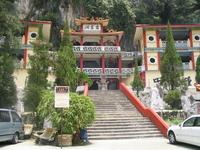
Perak Tong |
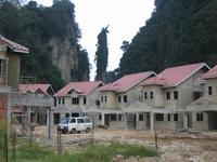
new houses close to limestone hills |
Travelling from KL to the east coast on the highway, the first hill you see (after Batu Caves) is Gua Cinta Manis near Bentong, just before Karak. Then the next and only other hill visible from the highway (but in the distance) is Gunung Sagu in the Kuantan area.
Turning off the highway at Bentong takes you to Raub, and on past lots of limestone hills in Pahang. These continue beyond Merapoh which is close to the state border of Kelantan. The town of Gua Musang is surorunded by limestone hills. The railway line (the "jungle train") also passes through this area. There are also many hills around the Sg Nenggiri area, some of which are archaeological sites. To the east in Terengganu is Tasik Kenyir. Many of the limestone hills were drowned when the lake was created but some still remain above the water level.
The old trunk road from KL to Kuantan goes through Temerloh and turning off here leads to Gunung Senyum and Jebak Puyuh. Senyum is a recreation park and well visited. East of Jerantut are the Kota Gelanggi caves. The parks of Taman Negara which both contain caves, are also reached from Jerantut.
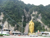
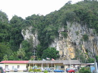
Batu Caves |
Gua Cinta Manis |
Gua Musang station |
Batu Baloh from Sg. Nenggiri
|
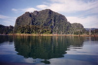
Bukit Bewah, Tasik Kenyir |
It is still possible to find 'new' (i.e. unrecorded) limestone hills in Malaysia. Due to the restriction of topo maps until recently, and the fact that many areas were offlimits due to the Communist threat left over from The Emergency (~1948 to 1960), many remote areas have not been explored. Some areas were offlimits or restricted even until the early 1990s.
Some limestone hills have not been recorded in geological or other literature. In 2008 one such hill was found in Kedah, at Ulu Muda. It was found by locals who were trekking in the area and was not shown on geological maps of the area. According to WWF, the Ulu Muda forests in the north-east of Kedah cover an area of more than 160,000ha (35% of the total forested land area of Kedah). Known as the Gua Labua limestone hills, they are currently the only known limestone outcrops between Baling to the south and the Thai province of Yala in the north. There are 2 caves in the larger hill.
© Liz Price 2007- 2012
Last updated 1 July 2012
|